
Wild weather characterizes June
July 5, 2018
Pat Ridenour
Denizens of Southeastern Montana, and indeed much of the state, are enjoying one of the finest and most prolific spring growing seasons in memory and in fact in history.
Dryland alfalfa hay is one of the finest, following years of semi-drought, with 2017 ranked as one of the worst years ever. With the abundant rain, western wheat grass is now heading out too, belly-button high on a tall horse. Grain crops are showing strong also.
Ranchers are still busy dodging storms to get their hay up. Some have had windrows down since before the mid-month soaking.
This spring of rebirth also follows one of the meanest winters in history.
The weather remains cool going into early summer, and residents have turned on their heat more than their seldom-used air conditioning.
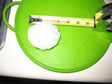
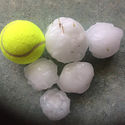
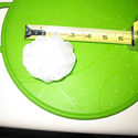
June went out with a bang and roar, as severe storms swept across the area Thursday, bringing considerable rain and scattered hail. As many as five tornadoes touched down in Eastern Carter County and into South Dakota, near Capitol, Montana. Huge hail stones fell in parts of the area, some as large as baseballs, and the heaviest were quite capable of killing or causing severe injury, to anything they struck. Photos posted on Facebook showed many of the larger stones were also not round, but jagged, nasty looking killers.
The majority of the area escaped without severe damage, but there were reports of lost crops, shattered windows and smashed vehicles and roofs to the west and north of Broadus. In Broadus, small hail fell thick and stripped leaves of trees, but did little actual damage.
There are also still spots in eastern Powder River County and western Carter that have not received the moisture the rest of area has enjoyed.
At the Broadus NWS station kept by the Sheriff's dispatch, June rain totaled an outstanding 5.35 inches of moisture. The highest single day total was 2.17 inches on June 16. The station reported .75 inch on the 28th, but others around town had much more. Billy's new station at the Examiner's Office showed well over an inch that same day.
That comes after a fine April and May, with 1.98 inch received in April, and 2.67 inches in May, 2018.
The norm for June in Broadus is 2.25 inches. Last year in June, only .92 inch of rain fell, in scattered, small storms that did little good to pasture and hay.
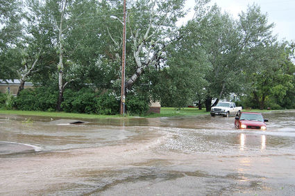
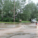
A brief but heavy storm passed over Broadus on Friday, dumping over an inch of rain in a very short period. In the picture below, a driver wisely decides to go around the deepest part of the "river" on the street between the clinic and post office. Note the water running up and around the bridge, at left.
Other areas received more or less, as most of the severe storms were spotty. Biddle, for instance, got only 1.44 as measured at the Mader Station. With 1.64 in May and 1.26 in April, totals there are less, in an area that normally receives more.
Ekalaka received a nice 3.5 inches of June moisture, but in the Boyes, Hammond country there was much less. There are no NWS stations in that area.
The Mizpah Station reported 3.90 inches for June, as did four other stations.
Moorhead's 9 NE station logged in 3.90, and the Sonnette 9SW station reported 3.90 also.
At the Powderville 8NNE station they became the fourth NWS site in the area to measure 3.90, in a strange twist.
Barb Coulter at Broadus Insurance, which has customers across a huge area, said that 9 calls to report damage has came in thus far, from the storms Thursday. "The claim calls were from pretty much all over, from the Ashland Area to Miles City," she said. The hail and wind left vehicles and property damage in its wake.


Reader Comments(0)