
Flooding occurs along Powder & Tongue Rivers
June 6, 2019

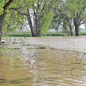
The local whitetail were not overly thrilled with the flooding of their forest homes. The pair pictured above were photographed moving through the deepening floodwaters to reach higher ground.
A series of storms which dropped heavy amounts of precipitation in Wyoming were responsible for rising waters along the Powder and Tongue Rivers over the past week.
At Moorhead Bridge, upstream from Broadus on the Powder River, the USGS gauge peaked at 10.77 feet, on May 31st. This compared to 13.27 feet during the April flood of 1965, and 15.24 feet during the May flood of 1978. The all-time record was 19.0 feet, in 1923.
From reports we've heard, this year's flooding was high enough to flood through some low riverbends along the drainage, though for the most part the river stayed within its banks. A few low-lying fields were flooded but damage seemed to be minimal.
The highest waters occurred from approximately Friday to Monday, depending on one's location along the river. At Moorhead, peak flows occurred May 31st at around 4 PM, at 11,800 cubic feet per second. At the Locate gauge site, flows didn't peak until Monday morning.
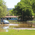
Flooding along the Tongue River was more widespread, especially around Ashland.
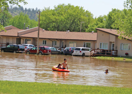
Despite the flooding in St. Labre, the local kids still found a way to have a good time, swimming and playing in the floodwater around their homes.
The Tongue peaked at Ashland in the early morning on June 2nd, with flows just over 4,500 cubic feet per second. This caused flooding into St. Labre village. In speaking with St. Labre locals on Sunday, the water came close to flooding homes, with water blocking off the entrance to the community for some time. Fortunately, no one was officially flooded out of their homes, and by Sunday morning the water levels had already begun to drop.
Due to the high flows being let out of Tongue River Dam, the campground just downstream of the dam was closed earlier in the week.
The Rosebud County Sheriff's Office indicated Monday that they had not heard of anyone along the Tongue being flooded out.
The highest recorded flows on the Tongue River at Ashland came in May of 1978, with 8340 cubic feet per second recorded.


Reader Comments(0)