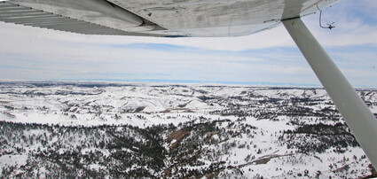
Relentless Winter Holds On Into April
April 6, 2023

While spring is close at hand in the lowlands, winter has been long lasting in the higher elevations of the county. The photo above was taken by The Examiner near Bradshaw Creek on April 1 (previous to the Monday/Tuesday storm) in the southern reaches of the county, looking towards the Big Horns.
The weather in Southeastern Montana during February and March wasn't the worst – we've certainly seen colder and snowier late winters. One way to describe the late winter this year was relentless; it just wouldn't let up, lingering long into spring, and long past its welcome.
February and March both were punctuated by below average temperatures and storms that seemed to blow through the area on a weekly or bi-weekly basis. The storms didn't drop a lot of snow in the low country, and Broadus only had one short bout with temperatures in the double digits below zero, but the relentless winter persisted.
In February, temperatures started out fairly nice and hovered around normal, topping out at 57 on Valentine's Day, but that high also signaled as shift, as soon after the weekly snowstorms kicked in. The mercury fell to -26 on February 23rd, and Broadus received 0.80" of precipitation in the form of snow in February. Normal February precip is 0.52".
Other areas, especially to the south and west received significant snowfall. The Moorhead 9 miles NE station had 10.0" of snow in February, and 14.6" in March. The Sonnette 7 miles SW station 19.5" of measurable snowfall in February, and 12.2" in March.
The Biddle 8 miles SW station had 10.5" of snow in February, and another 8.0" in March. The Powderville 8 miles NNE station had 7.7" of snow in February and 10.2" of snow in March.
The Sonnette station had the coldest readings in February, at -29 on February 23rd.
A cold snap around the 8th-10th of March provided dire cold for baby lambs and calves born into the cold – the Biddle station had a low of 2 on the 8th, Sonnette had -1 on the 9th, and other areas experienced single digit temps. The Sonnette station also recorded a -4 low on March 18th, which was a record low for that date at that station, with data recorded for March back to 1966.
If March felt cold, it's because the average temperature for the month at weather stations around the area hovered around 10 degrees below average.
April started out quite windy. Max wind gusts on Sunday at the Fort Howes RAWS station topped out at 42.0 mph and the same in Ekalaka.


Reader Comments(0)